Generation of vector maps from OpenStreetMap data. Supports area:highway tagging, works well for tiny areas (single crossing), neighbourhood maps - or of a single forest/airport/etc. Will work for entire town, villages - maybe even entire cities.
See also other map styles, allowing generation of other maps from the same OpenStreetMap data.
(there is more text below map, you can also see an animation showing how this tool is supposed to work)
- Move map to a small area interesting for you (a single crossing will work, generating a map of Poland will fail).
- Press the "rectangle" button, choose an area of interest.
- Wait - waiting several seconds is normal, currently no real progress info is displayed during download. Not even progress bar animation is shown when map is generated in your browser, it may take a bit.
- The generated map should appear below the map used for selecting. There is also a download button available below the generated map image.
- Use this map for something!
Map style has support for areas such as buildings, water, parks, forests, road areas and linear features such as roads, railways, waterways, taxiway, runways. Produced SVG files can be downloaded.
Examples
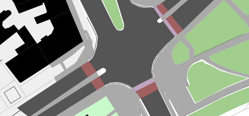
Example of a map generated from OpenStreetMap data, on ODbL license.
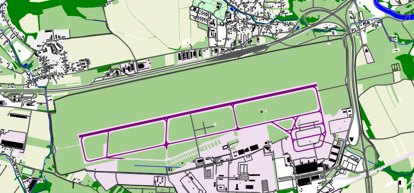
Example of a map generated from OpenStreetMap data, on ODbL license.
Even more info
Have fun with using OpenStreetMap data for interesting and/or useful purposes! Just remember that you must mention the source of data in a way visible to whoever will be using it. See this page for details, including cases where it is legally allowed to avoid giving a clear credit (but I encourage to do this in all cases).
If you liked this tool, something was confusing - you are welcomed to comment about it by creating a public issue or by sending me an email. You can also post a comment in OSM diary entry.
If you want to help mapping and you are unsure how to start - you can try StreetComplete (an Android app) allowing contributions, with sole requirements being (1) ability to read (2) ability to see things (3) ability to create an OpenStreetMap account.
If you want to map something (map missing objects, fix a mistake) and you are unsure how to start - visit openstreetmap.org, zoom in to interesting area and press the "edit" button and follow instructions. You can contact the OpenStreetMap community using one of global or local channels listed at community.osm.be and ask for help.
You can visit matkoniecz/lunar_assembler to see code, obtain code or contribute. This software is AGPLv3 licenced.